Lat: 46 27.77′ S
Long: 115 42.94′ W
Inst Speed: 15.4
Wind Dir: 261
Wind Speed: 26.1
Distance last 24hr: 345.65
Distance to finish: 10750.85
Long: 115 42.94′ W
Inst Speed: 15.4
Wind Dir: 261
Wind Speed: 26.1
Distance last 24hr: 345.65
Distance to finish: 10750.85

Theirry watching the waves carefully
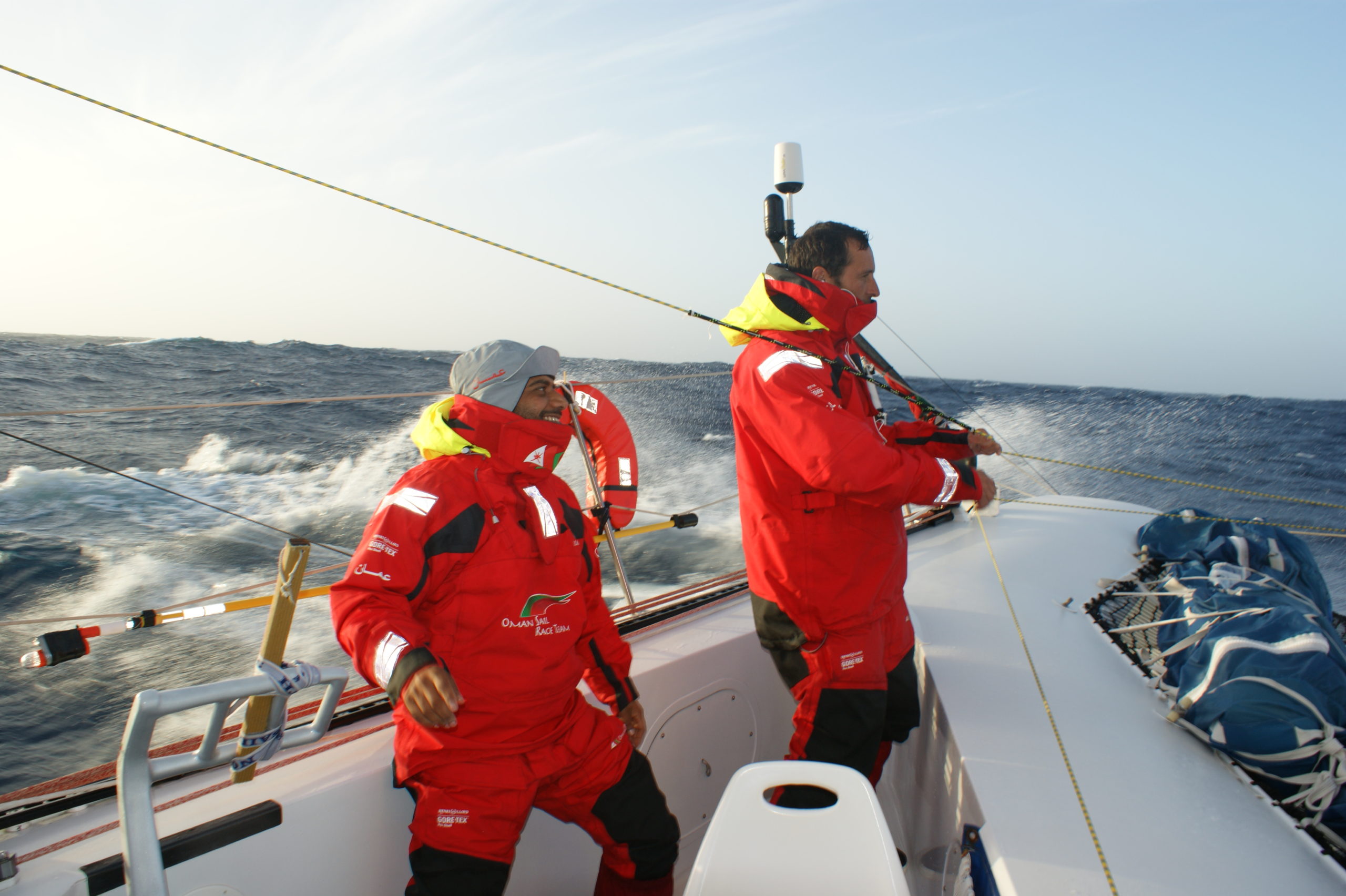
19kts down ‘hill’
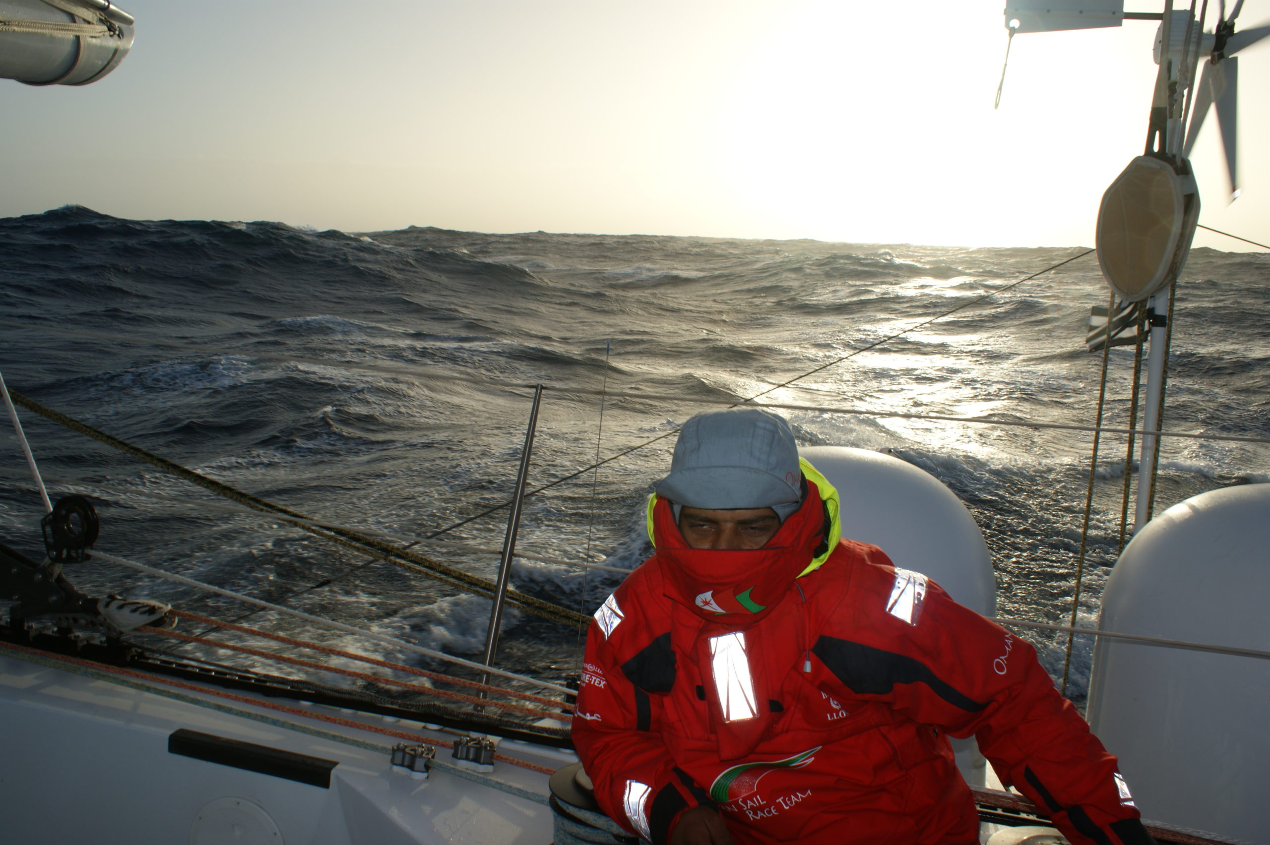
on watch in the ‘south’
Email from the boat to shore:
From: OmanTri
To: update
Subject: Wednesday am
Date: 11/02/2009 02:23:15
It’s so hard to know what to write at the moment – every day seems fairly
similar to the last. We are moving along in petty rough seas, not the giant
rolling swells that we were expecting, and some life onboard is reduced a
fair bit to eating and sleeping and sailing. much less reading or writing
anything.
We had our first big blow ( still 28-33kts wind) where we saw up to 48kts
of wind, and rough seas, but generally as we are not as fast ( due to the
seastate) as expected the strongest winds have passed us for now.
I guess the biggest news for us is that we crossed a line that we decided
was half way..it’s a bit arbitary, but we drew it a while ago and haven’t
moved it so it felt like the right place ! It was dark of course, and we
slipped across without anyone watching – again the sea condtions reducing
life to a minimum. I guess there is a point in every trip like we have come
a long way and yet there is still a long way to go – and it’s probably only
natural to feel that at the 1/2 way point! It’s great to be heading back
to Muscat, rather than away from it – but in reality we have always been
heading back to Muscat…..so it’s easy to pick a highpoint, then reduce it
down…. a little of glass half emptyness creeping in. The good news is that
we are almost certainly within a week of cape horn – and yet you look at
the chart and it’s still a long haul – especially if we don’t see any
improvement in the sea conditions. In 30 kts of wind we can usually sail
safely at 22-25 kts of boatspeed – in these seas we are sailing at closer to
an average of 15 – still very respectable by any normal sail boat
standards – but it feels dreadfully slow – in an ocean that promises so
high milage days. We all agreed on deck earlier that the Pacific hasn’t been
that great to us on the sea state front, and have rather given up on it –
hoping the south atlantic might provide something better.
A good indication of our progress is the time of darkness – it’s now falling
dark at 330am, and this does seem to change enough each day to notice it,
and rather than being on a treadmill we are making progress eastwards – it’s
a huge relief! Our jet lag, is there though – it’s still quite hard to know
what day we’re on, and being back in the atlantic and heading towards south
africa will cure this – again some 3 weeks away !!! ( not sure why we kid
ourselves by looking so far ahead! )
We shouldn’t complain too much though – although the seastate was bad for
the first 12 hrs today, and slightly improved for the 2nd the sky couldn’t
be more different – fog, drizzle and rain, initially gave way to blue skies,
and warm winds which despite the water over the decks is so welcome compared
to earlier. The sun does certainly have a positive effect on moods, and it’s
great to have seen it so much so far on this trip – even at 46S where we
expected much worse weather.
Weather Router’s advice:
From: Commanders’ Weather
To: Musandam
Subject: weather
Date: 11/02/2009 12:48:55
To: Charles Darbyshire and the crew of
“Musandam”
From: Commanders Weather Corp
Event: sail around the world
Last Position: 45 44s/118w at 1200utc Wed Feb 11, 2009
Prepared: 1230utc Wed Feb 11, 2009
SummaryÖ Another round of very strong winds likely from around 00utc Fri
thru 0600utc Sat ñ again, very large seas as well
Continue to be cautious
1) Intense low pressure down around 57s/111w is moving ESE and further away
2) Another low, around 55/141 with front extending west of 135w
a) additional low pressure will develop along that front as it moves E
3) WSW flow will clock over the next 24 hours
a) wind speeds will slowly come down
4) By 12utc Thurs, low pressure will be near 54s/137w with front extending
NE to another low near 46s/123w
a) the northern low will head and intensify
5) As the front pushes E, flow will increase again after 12utc Thursday
6) There will be another potent low near 53s/105e on Fri
7) Strong cold front from the low will extend to 45s/103w then NW from there
a) the front will move rapidly E and likely pass you sometime around 18utc
Fri
8) Strong NW winds ahead of the front, likely 30-45 kts with gusts to 50 kts
a) core of strongest winds may be around 44 30s-46s on Fri
9) May have some squalls around the front
10) Flow backs and becomes more W and WSW behind the front
11) Wind still quite strong, but not as much as ahead of it
12) Will be very rough Fri with the big winds and large seas
13) WSW flow then should persist into the beginning of the weekend
a) flow will clock and diminish during the course of the weekend
14) Next low likely will come further north and will help keep flow clocking
as we get to Sun night and Mon
a) wind may become NE to ENE for a time as we get to Mon then shift to the
S and SW Mon night/Tues
RoutingÖ suggest more SE heading with the wind more left the next few hours
then a more or less E heading with the clocking flow ñ SE heading
around/after 12utc Fri – Some estimated positions below
Wind directions are TRUE, wind speed in kts, and time is UTC
Wed Feb 11
18: 270-290/25-35
WeatherÖCloudy with a few scattered showers or a squall
Seas 15-22 ft ñ a W swell
Thu, Feb 12 – more wind S, less N
00: 270-290/22-32
06: 280-300/15-22
12: 310-330/15-20 nr 46 15s/109 15w
18: 300-320/20-30
WeatherÖPartly cloudy to cloudy
Seas 13-18 ft with a W swell ñ seas come down for a time then will increase
again overnight
Fri, Feb 13 – wind likely becomes strongest between 44 30s-46s, a bit less
south from 00utc thru 12utc
00: 310-330/25-35
06: 300-320/25-35, g40
12: 310-330/32-42, g45-50 nr 46 50s/99w
18: 270-290/30-40, g45-50 front -heading SE
WeatherÖCloudy with showers/few squalls developing
Seas building to 17-25 ft ñ W swell ñ biggest seas to the south
Sat, Feb 14
00: 260-280/30-40, g45
06: 260-280/25-35
12: 260-280/22-32 nr 50 10s/90 20w
18: 260-280/20-30
WeatherÖCloudy with showers/squalls
Seas of 17-25 ft and mainly from the W, diminishing late
Sun, Feb 15
00: 250-270/20-26
06: 250-270/20-25
12: 260-280/18-24 nr 53 50s/81 20w
18: 290-310/15-20
WeatherÖVariable clouds with an early shower.
Seas come down to 10-15 ft
Mon, Feb 16
00: 330-350/15-20
12: 050-070/12-17 nr 55 45s/73w
WeatherÖVariable clouds.
Seas 7-11 ft
Best regards, George Caras
—
PLEASE NOTE: AS OF JANUARY 1, 2008, OUR NEW EMAIL ADDRESS IS :
info@commandersweather.com
Commanders Weather Corp.
Tel: 603-882-6789
A selection of pictures from today: