Lat: 46 01.62′ S
Long: 129 38.23′ W
Inst Speed: 16.3
Wind Dir: 285
Wind Speed: 31.2999
Distance last 24hr: 245.8646261357474143
Distance to finish: 11258.36
Email from the boat to shore:
From: OmanTri
To: update
Subject: 24hours of change
Date: 10/02/2009 05:54:28
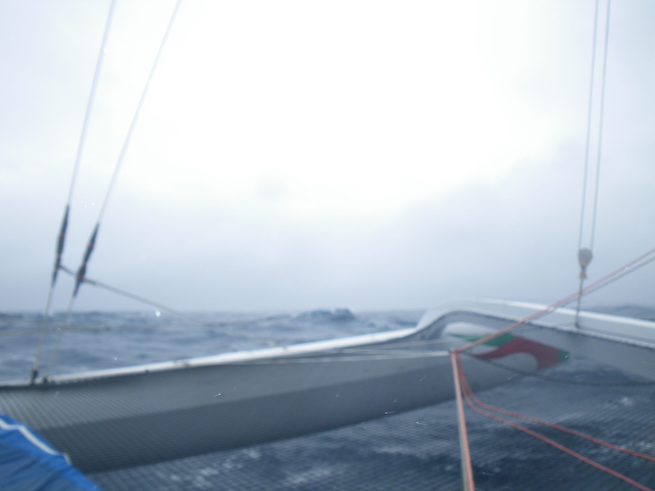
Since the last update we’ve been moving east as conditions have allowed-
the wind direction has been through every direction on the compass ( as
forecasted) and we have had fog, drizzle, sunshine, fairly flat seas, and a
building swell – so it’s been all change – every time you go below
something changes when you next appear on deck.
We have been waiting for the low to pass ahead of us – which it now has, and
then we have been waiting for the breeze to build from the NW which is now
is doing. We have had full main and gennaker in the sunshine, and as the
local afternoon wore on the grey clouds on the NW horizon gathered – and
signaled our first southern ocean ‘blow’. we think that it’s last us for
around 36 hours, and expect winds to gust to 45 may be 50 kts, and for the
seas to build – we have had this coming for quite some time so everyone has
been getting a little exta sleep where possible.When it gets rough it may be
hard! Right now we have 30 kts of wind, 2 reef in the mainsail and the
solent jib, and have anything between 12 and 20 kts of boatspeed depending
on where we are on a wave. The swell is not yet that big – but before it
went dark you could look across from one peak to another – the valley
between them clear rather than the wind waves we have had before… the
southern ocean swell is coming. when it becomes daylight again we are
expecting the picture to be more typically southern ocean.
The sunshine was fantastic for the 3 or 4 hours that it lasted for , once
again the wet weather gear came out to dry a bit, seems a little pointless
when it’ll be damp again in just a few hours but it made us feel better – a
bit of house keeping!! Loik took on the southern sea shave challenge, and
seems to have come off with out too many nicks. The Hooch/Theirry watch
continues to be the talkative watch – with the two of them chatting away all
the way through thier watch, much to the amusement of those below, who hear
the latest phrase that Hooch the teacher is passing on to his willing
student.
We have 100 miles to go to our 1/2 way point – true to form it’ll be dark,
and all but the on watch will most likely be asleep – so we’ll probably let
it slip past quietly – just safe in the knowledge we are heading back to
Muscat, rather than away from it.
To: update
Subject: 24hours of change
Date: 10/02/2009 05:54:28
Since the last update we’ve been moving east as conditions have allowed-
the wind direction has been through every direction on the compass ( as
forecasted) and we have had fog, drizzle, sunshine, fairly flat seas, and a
building swell – so it’s been all change – every time you go below
something changes when you next appear on deck.
We have been waiting for the low to pass ahead of us – which it now has, and
then we have been waiting for the breeze to build from the NW which is now
is doing. We have had full main and gennaker in the sunshine, and as the
local afternoon wore on the grey clouds on the NW horizon gathered – and
signaled our first southern ocean ‘blow’. we think that it’s last us for
around 36 hours, and expect winds to gust to 45 may be 50 kts, and for the
seas to build – we have had this coming for quite some time so everyone has
been getting a little exta sleep where possible.When it gets rough it may be
hard! Right now we have 30 kts of wind, 2 reef in the mainsail and the
solent jib, and have anything between 12 and 20 kts of boatspeed depending
on where we are on a wave. The swell is not yet that big – but before it
went dark you could look across from one peak to another – the valley
between them clear rather than the wind waves we have had before… the
southern ocean swell is coming. when it becomes daylight again we are
expecting the picture to be more typically southern ocean.
The sunshine was fantastic for the 3 or 4 hours that it lasted for , once
again the wet weather gear came out to dry a bit, seems a little pointless
when it’ll be damp again in just a few hours but it made us feel better – a
bit of house keeping!! Loik took on the southern sea shave challenge, and
seems to have come off with out too many nicks. The Hooch/Theirry watch
continues to be the talkative watch – with the two of them chatting away all
the way through thier watch, much to the amusement of those below, who hear
the latest phrase that Hooch the teacher is passing on to his willing
student.
We have 100 miles to go to our 1/2 way point – true to form it’ll be dark,
and all but the on watch will most likely be asleep – so we’ll probably let
it slip past quietly – just safe in the knowledge we are heading back to
Muscat, rather than away from it.
Second email from the boat:
From: OmanTri
To: update
Subject: theoretical 1/2 way
Date: 10/02/2009 11:59:28
slipped by at around 11:46 1/2 way point ( theoretical )
v..rough
40+ kts gust to 49
direction is good for us though so course fairly ok
will try to get some video when it gets light in couple of hours
Date: 10/02/09
Time: 11:55:00
Posn: 4614.3628S 12700.6705W
Ave Boatspeed last 5 mins:17.59 ,
Ave TWD last 5 mins: 297
Ave TWA last 5 mins: -152
Ave TWS last 5 mins: 42.3
Ave SOG last 5 mins:19.19
Ave COG last 5 mins: 087
Ave Pressure last 5 mins:990.6
Sea Temp: 12.3
Air Temp Fwd cabin: 15.5
From: OmanTri
To: update
Subject: video
Date: 10/02/2009 14:25:31
Attachment N1: Roughdaylight.wmv
not sure if this conveys the actual motion….
in the front ‘ bedroom ‘ which moves around a bit more than the others it’s
really like being on a bunk in the back of a van going fast down and unmade
road….and as there are no instruments in there, i occassionally just out
of the bunk to run on deck to help out – only to find loik at the chart
table and everything is fine….
the sea is rough – it hasn’t settled on the long swells we had been promised
in the guide book… and looks likely it’ll be like this for at least
48hours……
To: update
Subject: theoretical 1/2 way
Date: 10/02/2009 11:59:28
slipped by at around 11:46 1/2 way point ( theoretical )
v..rough
40+ kts gust to 49
direction is good for us though so course fairly ok
will try to get some video when it gets light in couple of hours
Date: 10/02/09
Time: 11:55:00
Posn: 4614.3628S 12700.6705W
Ave Boatspeed last 5 mins:17.59 ,
Ave TWD last 5 mins: 297
Ave TWA last 5 mins: -152
Ave TWS last 5 mins: 42.3
Ave SOG last 5 mins:19.19
Ave COG last 5 mins: 087
Ave Pressure last 5 mins:990.6
Sea Temp: 12.3
Air Temp Fwd cabin: 15.5
From: OmanTri
To: update
Subject: video
Date: 10/02/2009 14:25:31
Attachment N1: Roughdaylight.wmv
not sure if this conveys the actual motion….
in the front ‘ bedroom ‘ which moves around a bit more than the others it’s
really like being on a bunk in the back of a van going fast down and unmade
road….and as there are no instruments in there, i occassionally just out
of the bunk to run on deck to help out – only to find loik at the chart
table and everything is fine….
the sea is rough – it hasn’t settled on the long swells we had been promised
in the guide book… and looks likely it’ll be like this for at least
48hours……
Weather Router’s advice:
From: Commanders’ Weather
To: Musandam
Subject: weather
Date: 10/02/2009 12:32:45
To: Charles Darbyshire and the crew of
“Musandam”
From: Commanders Weather Corp
Event: sail around the world
Last Position: 46 14s/126 58w at 1200utc Tues Feb 10, 2009
Prepared: 1230utc Tues Feb 10, 2009
SummaryÖRough with lots of wind and big seas now thru around 06utc Thurs
then another round of strong winds later Fri thru early Sat ñ could get
quite light Sun, but confidence low on that
Very big seas as well.
Be careful!
1) Low pressure has moved close to 55s/117w
2) Strong W flow generally north of 50s and not much we can do to avoid the
strong winds
a) wind speeds mainly 30-40 kts with a few gusts to 45-50 kts
b) wind may be 260-270 next several hours, then a little more right after
16-18utc
3) Flow will continue quite strong thru Wed, around 25-35 kts with a few
higher gusts (40+ kts)
4) Low pressure areas will continue to head eastward to the south of 55s
over the next few days
5) New low will be near 55s/135w around 12utc Thursday
a) cold front from the low will extend to another, weaker low near
46s/122w with the front then extending NW to 40s/130w
b) the front will be coming east
6) This will cause the wind to clock after 06utc Thursday
a) wind speeds also come down for about a 6 hour period
7) Flow will then increase quickly as front and low pressure along it head E
and ESE
a) low will be near 48-49s/113w at 00utc Fri and 510-52s/103w around 12utc
Fri
8) Strong NW winds of 30-40 kts and gusts to possibly 50 kts ahead of the
front
a) may be squally
9) Front passes around 18utc Fri with flow becoming more W and WSW
a) wind speeds may ease a little Sat, but still likely only coming down to
20-30 kts
10) Right now, looks like a WSW or SW wind persists Sun, too, with the wind
starting to clock Sun night/Mon
11) 00utc run of the GFS showed a big drop in the wind later in the weekend
as it tried to develop/bring east, a weak ridge of high pressure
a) for now, discounting that and leaning on strong low off to the SW of
Cape Horn later in the weekend and keeping stronger flow for you
RoutingÖ towards 47s/115w then to around 48s/105w
Some estimated positions below
Wind directions are TRUE, wind speed in kts, and time is UTC
Tue, Feb 10
18: 270-290/28-38, g45-50
WeatherÖConsiderable clouds with some widely scattered squally showers
Seas building to 15-22 ft W swell
Wed Feb 11
00: 275-295/25-35, g40
06: 275-295/25-35, g40
12: 275-295/25-35, g40 nr 46 55s/116w
18: 270-290/25-35, g40
WeatherÖCloudy with a few scattered showers or a squall
Seas 15-22 ft ñ a W swell
Thu, Feb 12
00: 270-290/25-35
06: 275-295/22-32
12: 280-300/20-25 nr 48s/106 10w
18: 320-340/15-20
WeatherÖPartly cloudy to cloudy
Seas 15-20 ft with a W swell ñ seas come down some late
Fri, Feb 13 ñ wind stronger S, a little less N
00: 310-330/20-25
06: 300-320/25-35
12: 290-310/30-40, g45 nr 48 10s/96 50w
18: 290-310/30-40, g50
WeatherÖCloudy with showers/few squalls developing
Seas 12-15 ft early, then building to 15-22 ft ñ W swell
Sat, Feb 14
00: 260-280/30-40, g50
06: 250-270/25-35
12: 250-270/25-35 nr 50 30s/87w
18: 260-280/20-30
WeatherÖCloudy with showers/squalls
Seas of18-25 ft and mainly from the W ñ diminishing seas overnight
Sun, Feb 15
00: 250-270/20-28
12: 240-260/18-24 nr 54s/81w
WeatherÖCloudy with a couple showers.
Seas come down to 10-15 ft
Best regards, George Caras
—
PLEASE NOTE: AS OF JANUARY 1, 2008, OUR NEW EMAIL ADDRESS IS :
info@commandersweather.com
Commanders Weather Corp.
Tel: 603-882-6789
A selection of pictures from today: