Lat: 42 44.87′ S
Long: 177 45.73′ E
Inst Speed: 13.2
Wind Dir: 136
Wind Speed: 18.1000
Distance last 24hr: 263.5
Distance to finish: 13388.98
Long: 177 45.73′ E
Inst Speed: 13.2
Wind Dir: 136
Wind Speed: 18.1000
Distance last 24hr: 263.5
Distance to finish: 13388.98
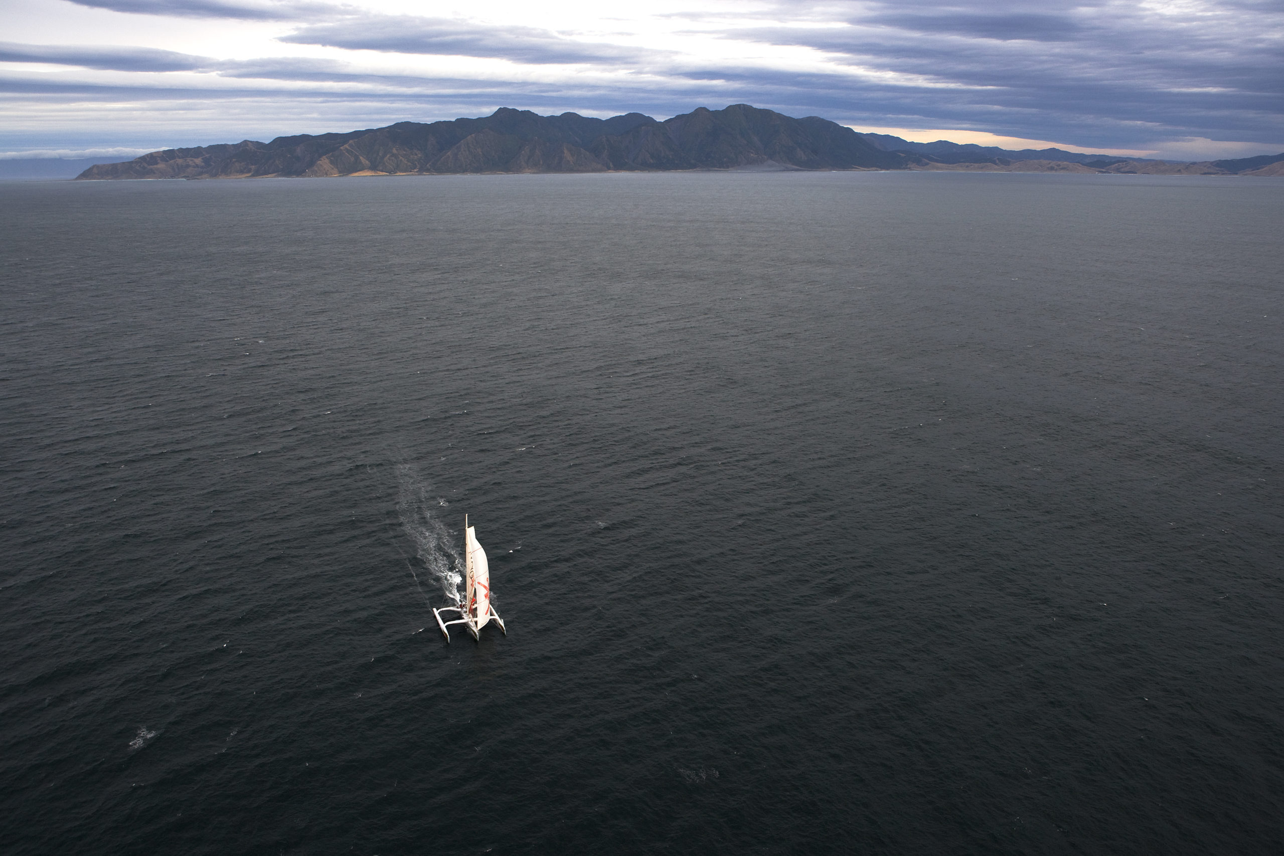
the dramatic landscape, last sight until cape horn
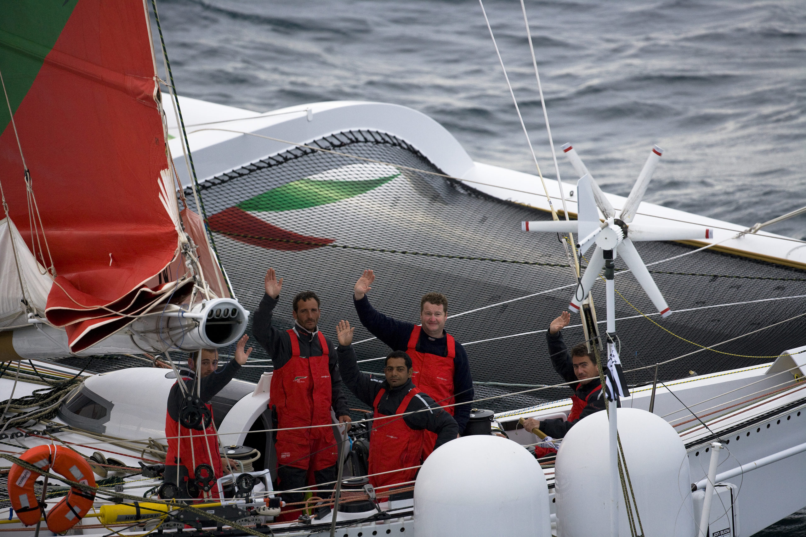
Waving good by to the heli – they flew close enough to see their faces
Email from the boat to shore:
From: OmanTri
To: update
Subject: 52kts in Cook Strait
Date: 04/02/2009 03:21:49
So after yesterday’s ‘massive’ 24hrs we were treated to yet another… in
more ways that one.
After catching sight of New Zealand’s Cape Farewell, we headed onwards into
Tasman Bay loosing sight of land once again.We had been getting wind reports
from the North Coast of South Island that showed good N winds so had planned
for them to arrive ‘any time soon’ with us. Needing to get East in any case
we continued on into Tasman Bay expecting at some point to get the N winds
and be naturally turned to the south.In fact that never happened and we had
to gybe south one we were 60nm North of Cook Strait – unfortunatly that put
us out of range of helicopter to take pictures at sunset, and a plan was
hatched to meet us south of the Strait after the night – the next problem
was that we may have been out of Heli range at dawn – we were heading South
very quickly – also the night was coming quickly and it promised to be be a
windy and dark night so reducing sail seemed a sensible option ( also
increasing the chance of a heli being able to reach us at dawn) As we headed
further and further south the wind started to funnel though between the
north and south island reaching a steady 35kts at time – with just 3 reefs
in the mainsail and no headsail we were in a safe mode, we sailed on past
the entrance to Wellington before reaching a point 3nm SW of ‘Windy
oint’ – the name should have given it away, 35, 40, 43, 47,50,52 kts of
wind screaming though the rigging, and getting pummled on deck with spray,
whiped off the sea’s surface and hurled into our wet weather gear so we
scrambled to get the main down and sail under bear poles dead downwind (
luckily out to sea) We continued like this and the wind dropped to 30 kts
again then 25, and we kept heading SE towards Cape Palliser ( the point we
had arrange to meet the Helicopter) As the sun rose were able to set sail
once more – perfectly timed to meet the helicopter to sail away from land
with 1 reef and gennaker at 20 kts+ of boatspeed. This after the heli had
suffered a bird strike during it’s first take off, and had to wait 20 mins
to clean the blades!
It was with mixed feelings that we waved good bye to New Zealand, due to our
trip into Tazman Bay, and the hours of darkness we had seen very little of
the land, just the fabulous coast of the Cape Palliser with it distinctive
light house – such a shame to pass something by so great without a chance to
see it properly – this is somewhere to go onto the must visit one day list.
Ahead of us lies the great expanse of the Pacific Ocean, when we hold our
small inflatable globe onboard it’s almost possible to hold it in a way
that is almost entirely free from significant land mass – just a huge blue
expanse, it’s a view most people have seen in the class room at some point,
moving their head from side to side trying to hide New Zealand and South
America – not many will go on to actually sail across it’s expanse – so we
are lucky to be here – even if we are taking the short cut across the
bottom. I guess the big question is what next – after focusing on NZL for so
long we have to focus on our next objectives, the International date line
is 100 nm away, our mythical half way point is next, and afterwards on to
cape horn, when wiill we reach Cape Horn – the million dollar question –
but we hope something around 14 days, less if we have a good run, more if we
don’t.
Second email from the boat:
From: OmanTri
To: update
Subject: international date line
Date: 04/02/2009 12:41:18
crossed the line at 12:37hrs 4th Feb UTC
now have W after the numbers of longitude!
To: update
Subject: international date line
Date: 04/02/2009 12:41:18
crossed the line at 12:37hrs 4th Feb UTC
now have W after the numbers of longitude!
Weather Router’s advice:
From: Commanders’ Weather
To: Musandam
Subject: weather forecast 2-4
Date: 04/02/2009 13:04:24
To: Charles Darbyshire and the crew of
“Musandam”
From: Commanders Weather Corp
Event: sail around the world
Last Position: near 43 16s/179 44w at 11 30 utc Wed Feb 4, 2009
Prepared: 1300utc Wed Feb 4, 2009
SummaryÖlooks as though you will stay ahead or to the S and E of the high
with very favorable S-SW to SW winds over the next 24-36 hrs, and then
eventually W-SW to W and NW ahead of the next cold front tracking to the E.
1) Cold front is off to the E and NE, while high pressure is now building E
to off South Island
2) You are E of this high with the brisk S-SW breeze, which will trend right
into SW over the next 24 hrs, as the high shifts to the E and E-NE
a) wind speeds getting into the lower 20s
3) The high will be located NW of Chatham Island near 42 30s/180 by 12 utc
Thu, then shifts E-NE to 42s/174w by 00 utc Fri to 41-42S/165-168w by 12 utc
Fri
4) As this high passes by to the north, look for winds to continue to trend
right into W-SW and then mainly W on Fri.
a) wind mainly in the 20s, but
b) there could be a period of 30-35 kts, near any squally showers
5) the high then shifts E along 40-41S into Sat, while the next cold front
advances to the E
6) Will be stronger W to NW winds ahead of this front, mainly later Sat into
Sun.
a) wind speeds into the 30s, and
b) there will be increasing chance for showers/squalls as this front
approaches from W
7) front moves thru sometime around 12 utc Sun with wind shifting into SW to
S behind it.
a) wind diminishes for a time, but
b) watch out for colder more unstable type clouds with showers, and
c) this may keep the S wind into the 20s and lower 30s
8) Cold front may slow down some into early next week, and
9) if you catch the front again, there is chance wind diminishes and shifts
into N or NE
10) but right now, think you remain with a wind shifting into SW, which may
increase from W to NW by Tue, if a big low forms over the southern Ocean.
RoutingÖ
1) a close to 130 course to south of Chatham Island to near 45s/175w looks
fine, and
2) as wind shifts into W-SW to W, you may need to get further south to
46s/169w before gibing back more north.
a) remember, you want to stay north of 48s to avoid any risk of ice
3) With the stronger NW winds ahead of cold front, you can head E or E-NE
along or between 44-45S, but
4) behind the cold front with the S winds, you may need to come up to 43S by
Mon or so.
5) in the longer term (Mon-Wed) of next week, looks best to be near 42-43S
with the potential big storm to the S produce more wind and sea
6) Estimated positions listed below
Wind directions are TRUE, wind speed in kts, and time is UTC
Wed, Feb 4
18: 190-210/ 15-22
WeatherÖmainly cloudy with chance for a squally shower
Seas 7-10 ft, SW swell
Thu, Feb 5 ñ wind lighter behind you to the W and NW, while stronger to the
S and SE
00: 200-220/ 17-24, just S or S-SW of Chatham Is
06: 210-230/ 17-25
12: 220-240/ 17-25 nr 45s/ 173w
18: 220-240/ 18-26
WeatherÖVariable cloudiness, risk for isolated passing squally shower
Seas building to 10-14 ft, wind wave chop with SW swell ñ higher to the S
and SE
Fri, Feb 6 ñ high pressure passing by to the north along 41-42S ñ so wind
lighter to the north, and stronger south
00: 240-260/ 24-32 nr 46s/169w ñ now gibing back more north
06: 240-260/ 20-28
12: 260-280/ 20-30 nr 45s/165 30w
18: 280-310/ 18-25
WeatherÖpartly to variable cloudy
Seas 10-15 ft, wind wave chop with SW swell
Sat, Feb 7 ñ heading E with stronger W-NW to NW wind ahead of cold front
00: 290-310/ 20-28
06: 300-330/ 20-30
12: 310-330/ 25-35 nr 44s/157 30w
18: 310-330/ 25-35
WeatherÖVariable to mostly cloudy with increasing chance for showers/squalls
Seas 10-15 ft, rough chop with SW swell
Sun, Feb 8 ñ cold front moving thru from W to E
00: 310-340/25-35
06: 320-280/22-32, squally ñ near cold front
12: bcmg 190-220/20-30 nr 43 30n/149w ñ behind cold front
18: 170-200/22-35
WeatherÖshowers and squalls, then variable cloudiness and turning colder
with isolated passing showers
Seas 10-15 ft, SW swell
Mon, Feb 9 ñ mainly SW flow behind cold front, but if front slows down or
stalls, then chance you could catch the front and get into a lighter NE to N
wind
00: 180-210/20-30
12: 200-230/20-30 nr 43s/141w
WeatherÖVariable cloudiness, showers possible
Seas near 10 ft, SW swell
Tue, Feb 10 ñ big low pressure possibly developing well south may provide
stronger W to NW winds
00: 270-300/25-40
12: 310-340/25-40 nr 42 30s/132w
WeatherÖincreasing chance for showers and squalls
Seas building to 15-20 ft
Outlook for Wed Feb 11
Lighter W-NW to W winds, mainly 15-25 kts. Seas near 15 ft
Best regards, Chris Wasserback
—
PLEASE NOTE: AS OF JANUARY 1, 2008, OUR NEW EMAIL ADDRESS IS :
info@commandersweather.com
Commanders Weather Corp.
Tel: 603-882-6789
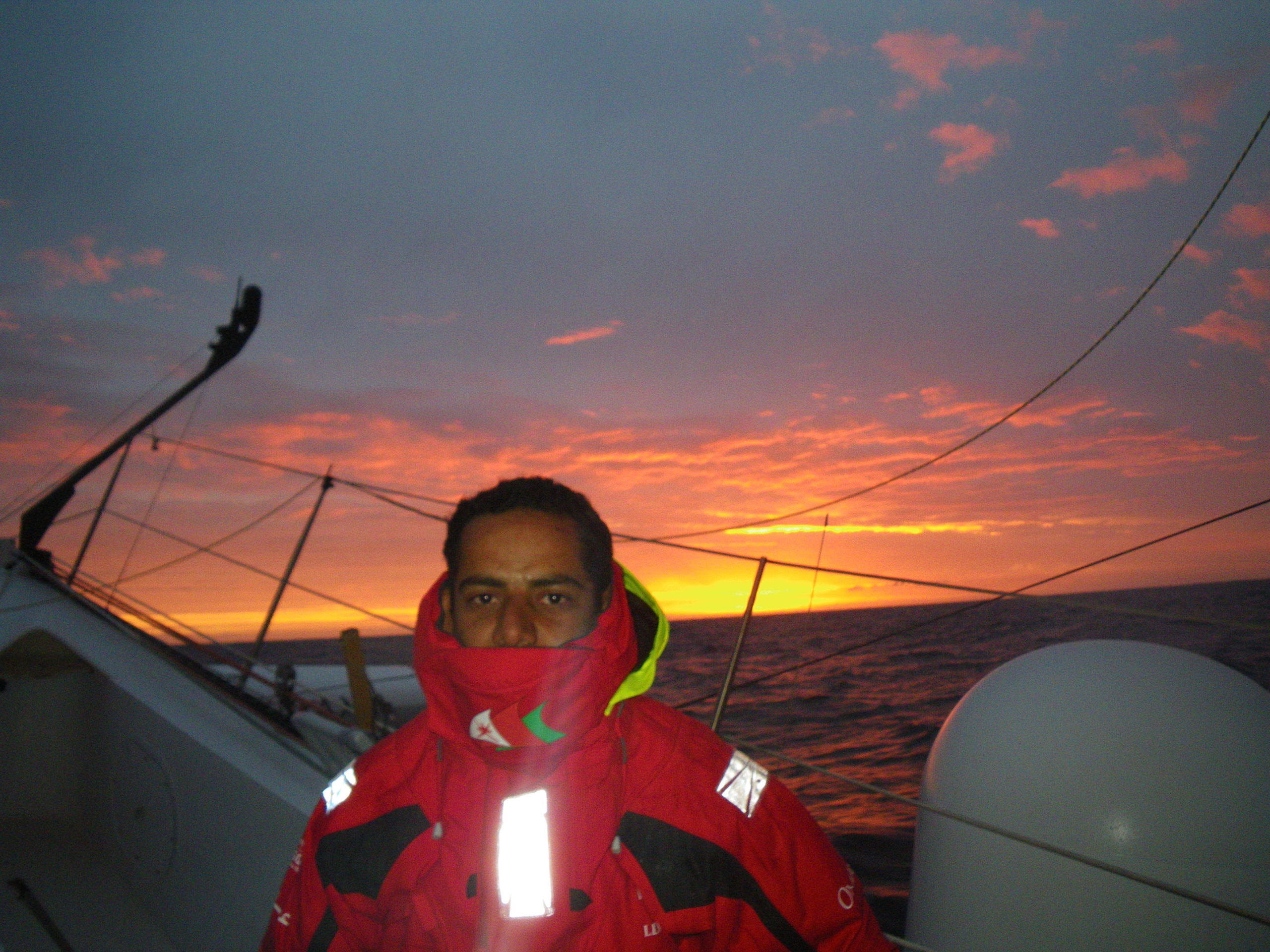
A selection of pictures from today: